Lake Travis Boating Hazards
Lake Travis water level is not constant. Hazards come and go as the water level changes. This is partial list of boating hazards on Lake Travis.
Saturday July 4
At current lake levels, be especially aware of 5 active hazards. Turn around, don't run aground.
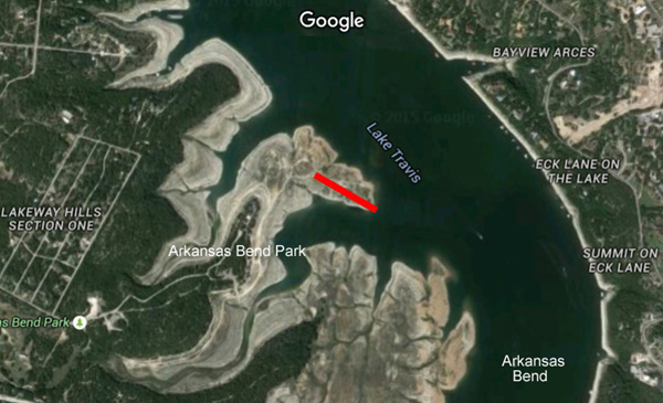
Travis Anegada
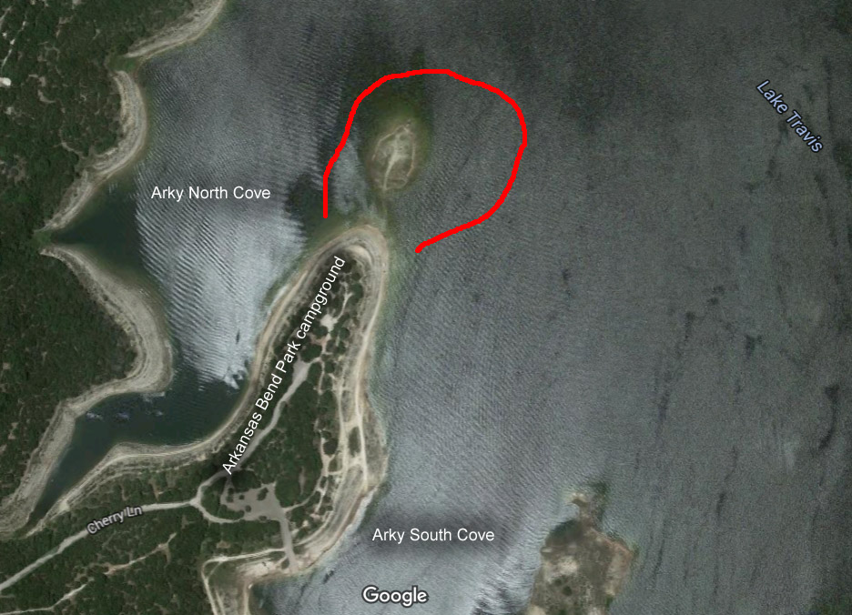
LCRA rarely marks the hazard called "Anegada," named for a low-lying island in the British Virgin Islands. Like its namesake, the rocks of Travis Anegada are just below the surface. As you approach Anegada, depth will gradually decrease, so pay attention to the sounder and be ready to turn about.
Anegada is located on the flats side of Arkansas Bend (west side of the lake) between the north and south coves of Arkansas Bend Park, north east of the campground on the point.
As lake elevation falls, Anegada becomes plain to see and the Wall at Arkansas Bend South Cove becomes a hazard.
Location (Google Maps):
N30° 24.480',W97° 56.784'
Dry elevation: 670'
Arkansas Bend Shortcut
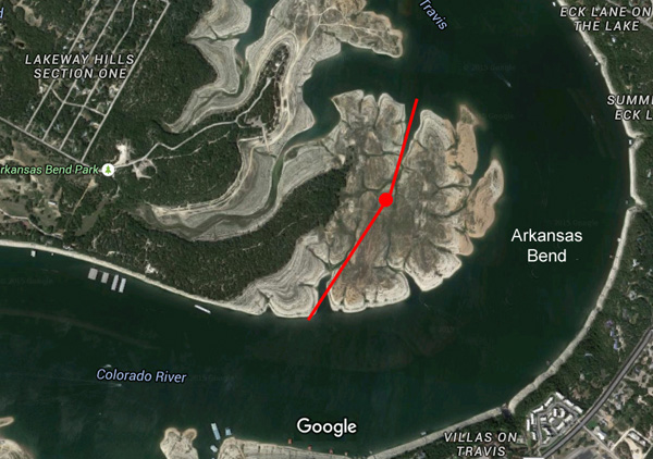
LCRA always posts hazard markers around the flats of Arkansas Bend. However, if the lake is full, perhaps you may decide to enter the marked hazard and take the shortcut. The shortcut is dry when the lake elevation is 670'. Check your boat insurance. If in doubt, don't do it.
The route from south to north:
ARCUT1 30° 23.893' N, 097° 56.747' W
ARCUT 30° 24.024' N, 097° 56.653' W (shallowest point)
ARCUT6 30° 24.078' N, 097° 56.600' W
ARCUTN 30° 24.175' N, 097° 56.560' W
Location (Google Maps):
N30° 24.024',W97° 56.653'
Dry elevation: 670'
Anderson Bend Shortcut
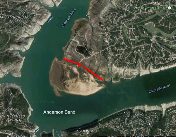
LCRA always posts hazard markers around the flats of Anderson Bend. However, if the lake is high enough, perhaps you may decide to enter the marked hazard and take the Anderson Bend shortcut. The shortcut is dry when the lake elevation is 660'. If in doubt, don't do it.
The route from east to west:
ANDERE N 30° 22.626', W 098° 0.535'
ANDER1 N 30° 22.692', W 098° 0.645'
ANDER2 N 30° 22.741', W 098° 0.708'
ANDER3 N 30° 22.744', W 098° 0.805'
ANDERW N 30° 22.815', W 098° 0.880'
Location (Google Maps):
N30° 22.720',W98° 0.678'
Dry elevation: 660'
Grelle Wall
To get to Grelle LCRA Park, go up the lake past Pace Bend, past the Pedernales River, past Muleshoe Bend, to Turkey Bend at Marker 47. This is where Krause Springs and Little Cypress Creek flow into Lake Travis. LCRA sometimes places hazard markers along a wall that blocks much of the entrance. Go through the break in the wall, then a half mile to reach the park.
The route from east to west then south:
GRELLE N30° 29.357', W098° 07.841'
GRELLE-1 N30° 29.340', W098° 07.956'
GRELLE-2 N30° 29.203', W098° 08.075'
GRELLE-3 N30° 28.871', W098° 08.079'
GRELLE-ANCHOR N30° 28.859', W098° 08.103'
Location (Google Maps):
N30° 29.345',W98° 7.839'
Dry elevation: 660'
Cow Creek
Cow Creek flows into Lake Travis near Marker 32. There are three hazards associated with Cow Creek:
Cow Creek is not a no-wake zone. Power boats race up and down the creek with no regard for those anchored.
There is a hairpin bend near the entrance, which LCRA usually marks. Stay close to the cliff walls.
The high-voltage power lines that span the entrance to Cow Creek are a hazard for tall-mast sailboats when the lake is full. As you enter, keep to the left to maximize the distance between the power lines and the mast top.
(I was there May 25, 2019, when electricity arced from the power lines to the aluminum mast of a 38-footer. The lake was full at 681'. It was a drizzly day. I went under the power lines with no problem, but the sloop behind me had a taller rig. It sounded like a cannon shot. Fortunately, no passengers were hurt. The boat was out of commission for a year.)
Location (Google Maps):
N30° 29.195',W98° 0.837'
Dry elevation: 640'
The Great Wall
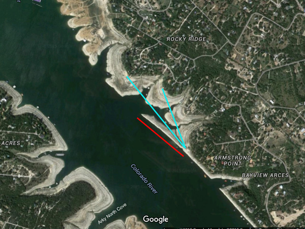
The Great Wall is a severe hazard that LCRA does not usually mark. The wall is 1/4 mile long and located 1/2 mile north of the campground at Arkansas Bend on the cliff side (east side) of the lake. The wall is dry when the lake elevation is 661' and hazardous at lake elevations below 668'.
You can assume wrongly that the wall is aligned with the points of land. In fact the wall juts into the lake. While heading easterly, you can go from 100 feet to 3 feet of water in seconds.
Location (Google Maps):
N30° 24.904',W97° 56.697'
Dry elevation: 661'
Graveyard Point
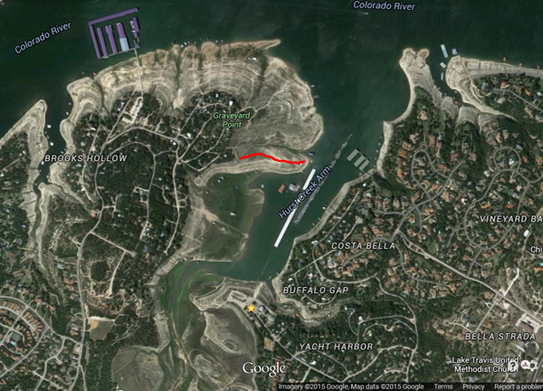
Graveyard Point is located on the west side of Hurst Cove, on the south side of the lake, 1.5 miles NE of Lakeway. Hurst Cove is the location of Sail & Ski Marina and Sundancer Grill restaurant. LCRA usually marks Graveyard Point on the lake side, but not on the cove side. It is a problem for boats leaving Hurst Cove at lake elevations of 662' and lower. To avoid the wall, stay close to the cliff wall on the east side.
Location (Google Maps):
N30° 23.266',W97° 57.463'
Dry elevation: 655'
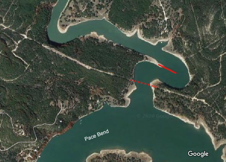
Wall at Arkansas Bend South Cove
As lake elevation falls, the south cove at Arkansas Bend Park becomes a nice anchorage because of a wall that rises out of the water, protecting the cove from lake wake. LCRA may place a shallow marker near this wall as it becomes a hazard. Be careful entering the south cove when the lake level is 653' or lower. From the shoals of Travis Anegada, the wall extends SE (107°) to approximately N30° 24.406', W097° 56.622' then drops off.
To safely enter the south cove, head west on latitude 30° 24.31' which is south of the wall and north of the hazard markers for the flats of Arkansas Bend.
Location (Google Maps):
N30° 24.362',W97° 56.567'
Dry elevation: 645'
Sometimes Islands Shortcut
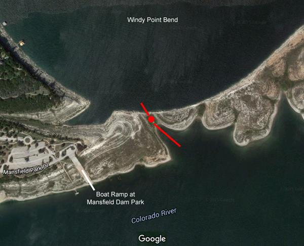
LCRA always posts hazard markers along Sometimes Islands. There is a shortcut across Sometimes Islands 1000' ENE of the boat ramp at Mansfield Dam Park. At lake levels below 645', approach the shortcut at its deepest point.
The route from north to south:
SICUTN N 30° 23.833', W 097° 54.070'
SICUT N 30° 23.824', W 097° 54.061'
SICUTS N 30° 23.810', W 097° 54.048'
From north to south, approach at SSE heading (140 degrees) crossing to the dam side of Sometimes Islands.
If in doubt, don't do it.
Location (Google Maps):
N30° 23.824',W97° 54.061'
Dry elevation: 629'